-
উপজেলা সম্পর্কিত
উপজেলা পরিচিতি
ইতিহাস ও ঐতিহ্য
ভৌগলিক ও অর্থনৈতিক
ইউনিয়ন
-
উপজেলা পরিষদ
জনপ্রতিনিধি
পরিকল্পনা ও প্রতিবেদন
মাসিক উন্নয়ন সমন্বয় সভা
নাগরিক সনদ
কর্মচারীবৃন্দ
বিভিন্ন কমিটির সভা
-
আইন শৃঙ্খলা বিষয়ক কমিটি
-
যোগাযোগ ও ভৌত অবকাঠামো উন্নয়ন বিষয়ক কমিটি
-
কৃষি ও সেচ বিষয়ক কমিটি
-
মাধ্যমিক ও মাদ্রাসা শিক্ষা বিষয়ক কমিটি
-
প্রাথমিক ও গণশিক্ষা বিষয়ক কমিটি
-
স্বাস্থ্য ও পরিবার কল্যাণ বিষয়ক কমিটি
-
যুব ও ক্রিড়া উন্নয়ন বিষয়ক কমিটি
-
নারী ও শিশু উন্নয়ন বিষয়ক কমিটি
-
সমাজ কল্যাণ বিষয়ক কমিটি
-
মুক্তিযোদ্ধা বিষয়ক কমিটি
-
মৎস্য ও প্রাণীসম্পদ বিষয়ক কমিটি
-
পল্লী উন্নয়ন ও সমবায় বিষয়ক কমিটি
-
সংস্কৃতি বিষয়ক কমিটি
-
বাজার মূল্য পর্যবেক্ষণ, মনিটরিং ও নিয়ন্ত্রণ কমিটি
-
অর্থ, বাজেট, পরিকল্পনা ও স্থানীয় সম্পদ আহরণ বিষয়ক কমিটি
-
জনস্বাস্থ্য, স্যানিটেশন ও বিশুদ্ধ পানি সরবরাহ বিষয়ক কমিটি
-
পরিবেশ ও বন বিষয়ক কমিটি
তথ্য প্রদানকারী কর্মকর্তা
-
আইন শৃঙ্খলা বিষয়ক কমিটি
-
উপজেলা প্রশাসন
উপজেলা নির্বাহী কর্মকর্তাবৃন্দ
ইউ এন ও এর কার্যালয়
এ্যাপয়ন্টমেন্ট ও সভা
সেবা ও অন্যান্য
-
সরকারি অফিস
আইন-শৃঙ্খলা বিষয়ক
স্বাস্থ্য বিষয়ক
কৃষি ও খাদ্য বিষয়ক
ভূমি বিষয়ক
প্রকৌশল ও তথ্য যোগাযোগ প্রযুক্তি
মানব সম্পদ উন্নয়ন বিষয়ক
-
অন্যান্য প্রতিষ্ঠান
শিক্ষা প্রতিষ্ঠান
-
গ্যালারি
- ফটো ও ভিডিও গ্য্যালারি
-
ই-সেবা
জেলা ই-সেবা কেন্দ্র
জাতীয় ই-সেবা
-
উপজেলা সম্পর্কিত
উপজেলা পরিচিতি
ইতিহাস ও ঐতিহ্য
ভৌগলিক ও অর্থনৈতিক
ইউনিয়ন
অন্যান্য
-
উপজেলা পরিষদ
জনপ্রতিনিধি
পরিকল্পনা ও প্রতিবেদন
মাসিক উন্নয়ন সমন্বয় সভা
নাগরিক সনদ
কর্মচারীবৃন্দ
বিভিন্ন কমিটির সভা
- আইন শৃঙ্খলা বিষয়ক কমিটি
- যোগাযোগ ও ভৌত অবকাঠামো উন্নয়ন বিষয়ক কমিটি
- কৃষি ও সেচ বিষয়ক কমিটি
- মাধ্যমিক ও মাদ্রাসা শিক্ষা বিষয়ক কমিটি
- প্রাথমিক ও গণশিক্ষা বিষয়ক কমিটি
- স্বাস্থ্য ও পরিবার কল্যাণ বিষয়ক কমিটি
- যুব ও ক্রিড়া উন্নয়ন বিষয়ক কমিটি
- নারী ও শিশু উন্নয়ন বিষয়ক কমিটি
- সমাজ কল্যাণ বিষয়ক কমিটি
- মুক্তিযোদ্ধা বিষয়ক কমিটি
- মৎস্য ও প্রাণীসম্পদ বিষয়ক কমিটি
- পল্লী উন্নয়ন ও সমবায় বিষয়ক কমিটি
- সংস্কৃতি বিষয়ক কমিটি
- বাজার মূল্য পর্যবেক্ষণ, মনিটরিং ও নিয়ন্ত্রণ কমিটি
- অর্থ, বাজেট, পরিকল্পনা ও স্থানীয় সম্পদ আহরণ বিষয়ক কমিটি
- জনস্বাস্থ্য, স্যানিটেশন ও বিশুদ্ধ পানি সরবরাহ বিষয়ক কমিটি
- পরিবেশ ও বন বিষয়ক কমিটি
সাংগঠনিক কাঠামো
তথ্য প্রদানকারী কর্মকর্তা
-
উপজেলা প্রশাসন
উপজেলা নির্বাহী কর্মকর্তাবৃন্দ
ইউ এন ও এর কার্যালয়
এ্যাপয়ন্টমেন্ট ও সভা
সেবা ও অন্যান্য
-
সরকারি অফিস
আইন-শৃঙ্খলা বিষয়ক
স্বাস্থ্য বিষয়ক
কৃষি ও খাদ্য বিষয়ক
ভূমি বিষয়ক
প্রকৌশল ও তথ্য যোগাযোগ প্রযুক্তি
মানব সম্পদ উন্নয়ন বিষয়ক
-
অন্যান্য প্রতিষ্ঠান
শিক্ষা প্রতিষ্ঠান
-
গ্যালারি
- ফটো ও ভিডিও গ্য্যালারি
-
ই-সেবা
জেলা ই-সেবা কেন্দ্র
জাতীয় ই-সেবা
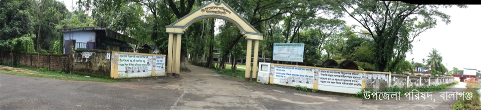
ছবিতে প্রদর্শিত গেইটটি বালাগঞ্জ উপজেলা পরিষদ কমপ্লেক্স -এর প্রবেশমূখে স্থাপিত একটি সুদৃশ্য স্থাপনা। বালাগঞ্জ উপজেলা সিলেট জেলার দক্ষিণ প্রান্তে কুশিয়ারা নদীর তীরে অবস্থিত অন্যতম বৃহত্তম একটি উপজেলা। এর উত্তরে সিলেট সদর উপজেলা, দক্ষিণে মৌলভীবাজার জেলার সদর ও রাজনগর উপজেলা, পূর্বে সিলেটের ফেঞ্চুগঞ্জ উপজেলা এবং পশ্চিমে সিলেটের বিশ্বনাথ ও সুনামগঞ্জ জেলার জগন্নাথপুর উপজেলার অবস্থান। ১৯২২ খ্রিস্টাব্দে গেজেট নোটিফিকেশন নং ১৭৬ তাং ১০/০১/১৯২২ মূলে বর্তমান বালাগঞ্জ উপজেলা এলাকা নিয়ে বালাগঞ্জ থানা পূণর্গঠিত হয়। পরবর্তীতে ৭ নভেম্বর, ১৯৮২ খ্রিঃ তারিখে বালাগঞ্জ থানা আপগ্রেডেড হয় এবং বালাগঞ্জ উপজেলায় রূপান্তরিত হয়।
The gate shown in the picture is a spectacular architecture that stands at the entry of the Upazila Parishad Complex.
The Upazila Balaganj stands on the river KUSHIARA and is on the southest periphery of Sylhet district. On the north, there is Sylhet Sadar(proper) Upazila, on the south, is Rajnagar and Sadar Upazila of Moulvibazar district, Fenchuganj Upazila of this district is on the east and on the west is Biswonath Upazila of this district and Jagannathpur Upazila of Sunamganj district.
Balaganj Upazila was first constituted as a Police Station(Balaganj Thana) including Balaganj, Fenchuganj and Rajnagar in 1882 AD. In 1922,Balaganj Thana got its new formation with its present territory vide gazette notification no.176 dated 10.01.1922. On 07 november 1982, Balaganj Thana was up-graded and declared to be Balaganj Upazila.


পরিকল্পনা ও বাস্তবায়নে: মন্ত্রিপরিষদ বিভাগ, এটুআই, বিসিসি, ডিওআইসিটি ও বেসিস
কারিগরি সহায়তায়:
![]()
সফটওয়্যার তৈরি: