-
উপজেলা সম্পর্কিত
উপজেলা পরিচিতি
ইতিহাস ও ঐতিহ্য
ভৌগলিক ও অর্থনৈতিক
ইউনিয়ন
-
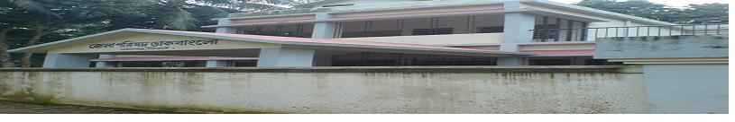
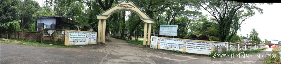
উপজেলা পরিষদ
জনপ্রতিনিধি
পরিকল্পনা ও প্রতিবেদন
মাসিক উন্নয়ন সমন্বয় সভা
নাগরিক সনদ
কর্মচারীবৃন্দ
বিভিন্ন কমিটির সভা
-
আইন শৃঙ্খলা বিষয়ক কমিটি
-
যোগাযোগ ও ভৌত অবকাঠামো উন্নয়ন বিষয়ক কমিটি
-
কৃষি ও সেচ বিষয়ক কমিটি
-
মাধ্যমিক ও মাদ্রাসা শিক্ষা বিষয়ক কমিটি
-
প্রাথমিক ও গণশিক্ষা বিষয়ক কমিটি
-
স্বাস্থ্য ও পরিবার কল্যাণ বিষয়ক কমিটি
-
যুব ও ক্রিড়া উন্নয়ন বিষয়ক কমিটি
-
নারী ও শিশু উন্নয়ন বিষয়ক কমিটি
-
সমাজ কল্যাণ বিষয়ক কমিটি
-
মুক্তিযোদ্ধা বিষয়ক কমিটি
-
মৎস্য ও প্রাণীসম্পদ বিষয়ক কমিটি
-
পল্লী উন্নয়ন ও সমবায় বিষয়ক কমিটি
-
সংস্কৃতি বিষয়ক কমিটি
-
বাজার মূল্য পর্যবেক্ষণ, মনিটরিং ও নিয়ন্ত্রণ কমিটি
-
অর্থ, বাজেট, পরিকল্পনা ও স্থানীয় সম্পদ আহরণ বিষয়ক কমিটি
-
জনস্বাস্থ্য, স্যানিটেশন ও বিশুদ্ধ পানি সরবরাহ বিষয়ক কমিটি
-
পরিবেশ ও বন বিষয়ক কমিটি
তথ্য প্রদানকারী কর্মকর্তা
-
আইন শৃঙ্খলা বিষয়ক কমিটি
-
উপজেলা প্রশাসন
উপজেলা নির্বাহী কর্মকর্তাবৃন্দ
ইউ এন ও এর কার্যালয়
এ্যাপয়ন্টমেন্ট ও সভা
সেবা ও অন্যান্য
-
সরকারি অফিস
আইন-শৃঙ্খলা বিষয়ক
স্বাস্থ্য বিষয়ক
কৃষি ও খাদ্য বিষয়ক
ভূমি বিষয়ক
প্রকৌশল ও তথ্য যোগাযোগ প্রযুক্তি
মানব সম্পদ উন্নয়ন বিষয়ক
-
অন্যান্য প্রতিষ্ঠান
শিক্ষা প্রতিষ্ঠান
-
গ্যালারি
- ফটো ও ভিডিও গ্য্যালারি
-
ই-সেবা
জেলা ই-সেবা কেন্দ্র
জাতীয় ই-সেবা
-
উপজেলা সম্পর্কিত
উপজেলা পরিচিতি
ইতিহাস ও ঐতিহ্য
ভৌগলিক ও অর্থনৈতিক
ইউনিয়ন
অন্যান্য
-
উপজেলা পরিষদ
জনপ্রতিনিধি
পরিকল্পনা ও প্রতিবেদন
মাসিক উন্নয়ন সমন্বয় সভা
নাগরিক সনদ
কর্মচারীবৃন্দ
বিভিন্ন কমিটির সভা
- আইন শৃঙ্খলা বিষয়ক কমিটি
- যোগাযোগ ও ভৌত অবকাঠামো উন্নয়ন বিষয়ক কমিটি
- কৃষি ও সেচ বিষয়ক কমিটি
- মাধ্যমিক ও মাদ্রাসা শিক্ষা বিষয়ক কমিটি
- প্রাথমিক ও গণশিক্ষা বিষয়ক কমিটি
- স্বাস্থ্য ও পরিবার কল্যাণ বিষয়ক কমিটি
- যুব ও ক্রিড়া উন্নয়ন বিষয়ক কমিটি
- নারী ও শিশু উন্নয়ন বিষয়ক কমিটি
- সমাজ কল্যাণ বিষয়ক কমিটি
- মুক্তিযোদ্ধা বিষয়ক কমিটি
- মৎস্য ও প্রাণীসম্পদ বিষয়ক কমিটি
- পল্লী উন্নয়ন ও সমবায় বিষয়ক কমিটি
- সংস্কৃতি বিষয়ক কমিটি
- বাজার মূল্য পর্যবেক্ষণ, মনিটরিং ও নিয়ন্ত্রণ কমিটি
- অর্থ, বাজেট, পরিকল্পনা ও স্থানীয় সম্পদ আহরণ বিষয়ক কমিটি
- জনস্বাস্থ্য, স্যানিটেশন ও বিশুদ্ধ পানি সরবরাহ বিষয়ক কমিটি
- পরিবেশ ও বন বিষয়ক কমিটি
সাংগঠনিক কাঠামো
তথ্য প্রদানকারী কর্মকর্তা
-
উপজেলা প্রশাসন
উপজেলা নির্বাহী কর্মকর্তাবৃন্দ
ইউ এন ও এর কার্যালয়
এ্যাপয়ন্টমেন্ট ও সভা
সেবা ও অন্যান্য
-
সরকারি অফিস
আইন-শৃঙ্খলা বিষয়ক
স্বাস্থ্য বিষয়ক
কৃষি ও খাদ্য বিষয়ক
ভূমি বিষয়ক
প্রকৌশল ও তথ্য যোগাযোগ প্রযুক্তি
মানব সম্পদ উন্নয়ন বিষয়ক
-
অন্যান্য প্রতিষ্ঠান
শিক্ষা প্রতিষ্ঠান
-
গ্যালারি
- ফটো ও ভিডিও গ্য্যালারি
-
ই-সেবা
জেলা ই-সেবা কেন্দ্র
জাতীয় ই-সেবা
বালাগঞ্জ উপজেলা ২৪,৬৬৬৭ ° N ৯১,৮৩৩৩ °E অবস্থিত । উত্তরে সিলেট জেলার দক্ষিন সুরমা উপজেলা , দক্ষিনে মৌলভীবাজার জেলার সদর ও রাজনগর উপজেলা, পূর্বে সিলেট জেলার ফেঞ্চুগঞ্জ উপজেলা এবং পশ্চিমে সিলেট জেলার বিশ্বনাথ ও সুনামগঞ্জ জেলার জগন্নাথপুর উপজেলা । আয়তন ৩৭৫.৭৫ বর্গকিলো মিটার। ছোট বড় বেশ কিছু হাওড় ও জলাশয় অধ্যুষিত বালাগঞ্জ উপজেলাটি প্রধানত সমতল ভুমি। উপজেলার দক্ষিন প্রান্ত ঘেঁষে কুশিয়ারা নদী পূর্ব পশ্চিমে প্রবাহিত হচ্ছে।
The Upazila Balaganj stands on the river KUSHIARA and is on the southest periphery of Sylhet district. On the north, there is Sylhet Sadar(proper) Upazila, on the south, is Rajnagar and Sadar Upazila of Moulvibazar district, Fenchuganj Upazila of this district is on the east and on the west is Biswonath Upazila of this district and Jagannathpur Upazila of Sunamganj district. Geographically Balaganj Upazila is situated at about 24.36* and 24.47* longitude and 91.38* and91.56* east latitude. The distance of the Upazila headquarter(HQ) from the district HQ is nearly 37 kms. The land areais approximately 375.75sq kms and the population is 255040(Census-2001).


পরিকল্পনা ও বাস্তবায়নে: মন্ত্রিপরিষদ বিভাগ, এটুআই, বিসিসি, ডিওআইসিটি ও বেসিস
কারিগরি সহায়তায়:
![]()
সফটওয়্যার তৈরি: